Streambank Restoration uses Natural Channel Design on Clarkesville Greenway - September 4, 201410/11/2018
In May, the Soque Partnership (led by the Soque River Watershed Association and City of Clarkesville) completed a streambank restoration project on Rocky Branch, a small tributary of the Soque River in the City of Clarkesville. The restoration site is located behind the Old Clarkesville Mill and adjacent to the Clarkesville Greenway Trail.
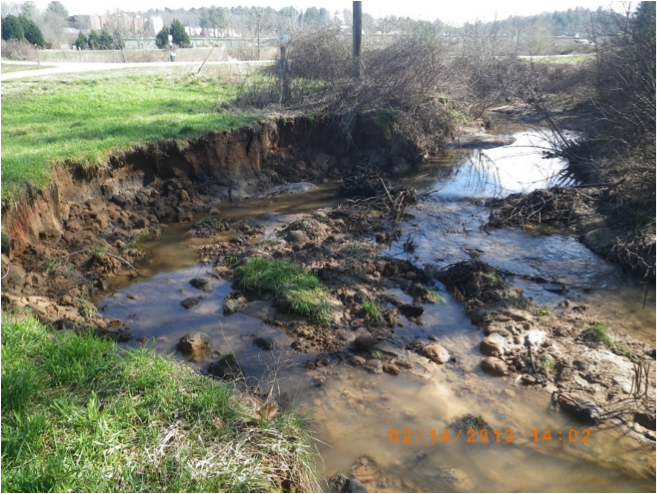
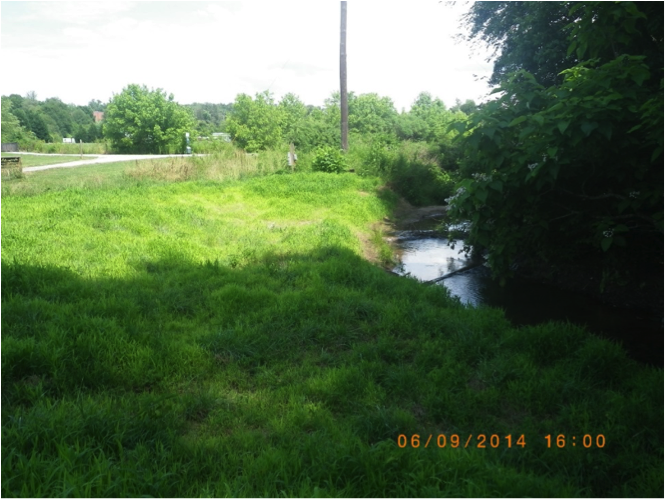
A 100-foot section of the streambank had been eroding for many years due to a number of exacerbating factors. Beaver had accumulated debris for a dam, which diverted a portion of the flow of Rocky Branch towards the bank causing localized erosion; the stream also lacked woody vegetation on the streambank to hold the soil in place and prevent the erosion; and excessive stormwater runoff from upstream in the Rocky Branch watershed increased the stress on the stability of the channel. Stormwater is rainfall that does not soak into the ground and runs off hard (impervious) surfaces like parking lots and rooftops carrying pollutants. As impervious surfaces increase, so does the volume of stormwater runoff, which can overwhelm a stream channel’s natural capacity to convey water. Eroding streambanks like the one on Rocky Branch are a common result and can lead to excessive erosion and sedimentation of adjacent streams. Excessive sedimentation is the leading cause of water quality impairment in the nation’s rivers, including the Soque River and Hazel Creek, a tributary to the Soque, which are considered impaired for habitat degradation to fish and wildlife due to sedimentation. Sediment clogs stream channels, degrades habitat for fish and wildlife, harms recreational fisheries, and increases the costs to treat drinking water. The Soque Partnership, which focuses on improving water quality in the Soque Watershed, utilized a unique approach to streambank restoration called “Natural Channel Design.” The approach utilizes scientific principles observed in nature to restore a stream to something resembling its historic functions, similar to a natural stream unaffected by human activities. Rather than armoring the banks with rip rap and stone, the technique allows the stream to overflow its banks by reshaping the slope giving easier access to a small floodplain. These new slopes are then thickly vegetated with native woody plants to provide stability to the banks by holding the soil in place. In addition to bank reshaping the project installed log vane structures in the stream to help direct the energy of the water into the center of the stream channel and away from the eroding bank. The entire area was covered and staked with erosion control matting made of biodegradable coconut fiber, and fast-growing warm-season grasses were planted to quickly establish vegetation. Later this year, larger native woody vegetation will be planted to establish a vegetated buffer along the stabilized stream segment. The project received funding support from a Clean Water Act grant from the Georgia Environmental Protection Division to address non-point source pollution. The Soque Partnership has received funds for such projects since 2004. Costs for the project were minimized by participation of City of Clarkesville staff and resources provided as match. The project was located on the City of Clarkesville’s 19-acre Greenway property. The results of the project can be seen while walking the Greenway Trail, with the restoration located behind a park bench near where the loop meets the trail.
2 Comments
Leave a Reply. |
AuthorSRWA Archives
October 2018
Categories |
 RSS Feed
|
srwa@soque.org
(706) 754-9382
|
|
P.O. Box 1901,
Clarkesville, GA 30523 Store front: 152 E Water St, Clarkesville, GA
|